Projects

The project utilises physiographic, satellite and airborne radiometric data to develop insights of the farming landscape that highlight the controlling factors affecting soil greenhouse gas emissions and water quality at catchment, farm and paddock scales. These insights will be used to create Landscape Resilience maps for several case study properties within the Matāura catchment.

Physiographics - The Science
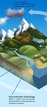
The fundamental background to the physiographic approach is that water quality outcomes vary spatially across the landscape, even when there are similar land use pressures. These differences are often the result of natural spatial variation in the landscape, which alters the composition of the water through coupled physical, chemical, and biological processes.

The Physiographic Environments of New Zealand (PENZ) is a three-year project that links fresh water to the land. Understanding this relationship is crucially important as it is a major influence over water composition, and hence quality.

Waituna Catchment - High Resolution Physiographic Units
Land & Water Science worked in collaboration with Living Water (DOC/Fonterra Partnership) and local landowners to undertake high-resolution physiographic mapping of the Waituna Catchment, Southland.

This project focuses on the catchment of Waituna Lagoon and identifies where small detainment dams could be constructed to control the surficial runoff of contaminants from the landscape. The sites are prioritised by capture zone size, the likelihood of overland flow, generated runoff volumes, and the possibility of contaminant load from various land uses.

Farm Scale Hydrology
This work looks at water movement and potential flow pathways at the paddock scale, identifying the locations where contaminants are leaving a property. This information can be used to inform better farm management decisions, or the placement of various mitigations or interventions, improving water quality.
